Laboratory facilities
| Aerial Photo and Visual interpretation: | 1. Light table 2. Stereoscope 3. Large format enlarger |
| Digital Image Processing and GIS software’s: | 1. ARCGIS labkit 2. ERDAS Imagine 3. IDRSI 4. GeoMedia RLL 5. QGIS 6. MapScape |
| GIS input / output: | 1. Digitizer board 2. Large Format Colour scanner-wide scan 3. R2V software 4. Large Format Designjet printer 5. A3-CYMK LAN enabled laser printer |
| Cartographic equipment’s: | 1. Planimeter 2. Scribing tools 3. Minidrafter |
| Ground truth collection: | 1. Multispectral Ground Truth Radiometer 2. VIS-NIR Hyperspectral Spectroradiometer 3. Data logger and chlorophyll meter |
| Database Library: | Archive of Satellite data 1. Hard copy format (FCC) 2. Digital data (PAN sharpened LISS3, mutlitemporal LISS3,AWIFS) |
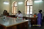
| Analytical laboratory: | 1. Soil testing 2. Water analysis 3. Plant analysis |
| Online Publishing: | 1. Server with ArcGIS IMS |